Storm Surge Watch
- Jupiter Inlet southward around the Florida peninsula to Bonita
Beach - Florida Keys
Hurricane Warning
- Dominican Republic from Cabo Frances Viejo to the northern border
with Haiti - Haiti from the northern border with the Dominican Republic to Le
Mole St. Nicholas - Southeastern Bahamas and the Turks and Caicos Islands
- Cuban provinces of Camaguey, Ciego de Avila, Sancti Spiritus, and
Villa Clara - Central Bahamas
- Northwestern Bahamas
Hurricane Watch
- Jupiter Inlet southward around the Florida peninsula to Bonita
Beach - Florida Keys
- Lake Okeechobee
- Florida Bay
- Cuban provinces of Guantanamo, Holguin, Las Tunas and Matanzas
Tropical Storm Warning
- Haiti from south of Le Mole St. Nicholas to Port-Au-Prince
- Cuban provinces of Guantanamo, Holguin, and Las Tunas
-A Storm Surge Watch means there is a possibility of life-threatening inundation, from rising water moving inland from the
coastline, in the indicated locations during the next 48 hours.
-A Hurricane Warning means that hurricane conditions are expected somewhere within the warning area. Preparations to protect life and property should be rushed to completion.
-A Hurricane Watch means that hurricane conditions are possible within the watch area. A watch is typically issued 48 hours
before the anticipated first occurrence of tropical-storm-force winds, conditions that make outside preparations difficult or dangerous.
A Tropical Storm Warning means that tropical storm conditions are expected somewhere within the warning area.
48-HOUR OUTLOOK
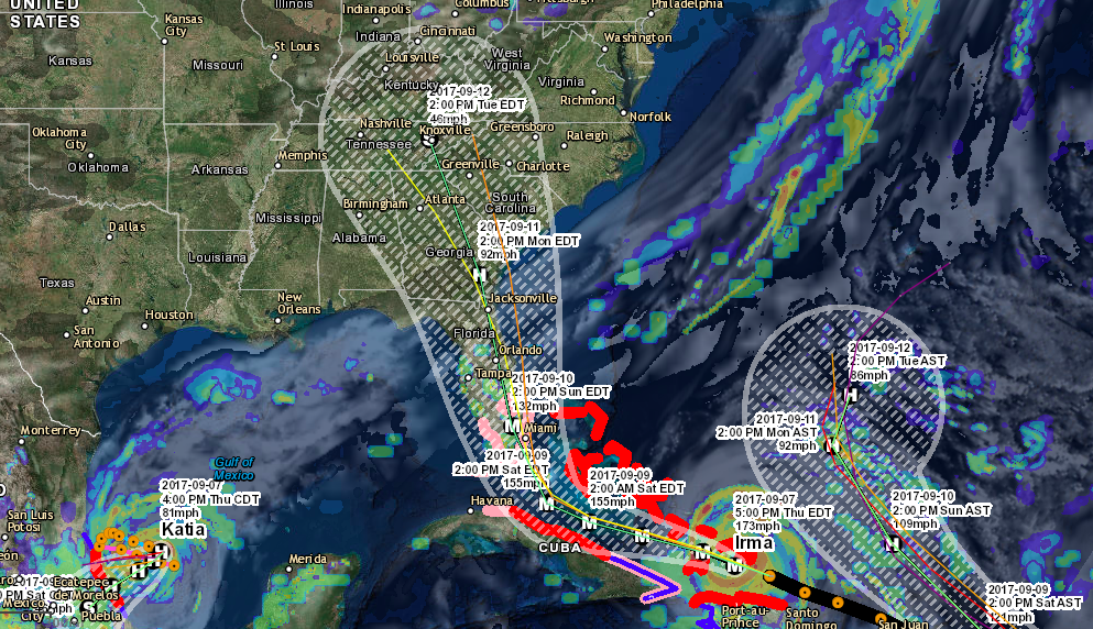
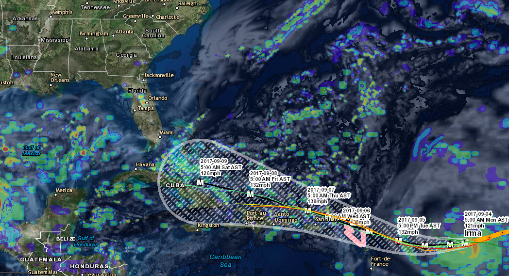
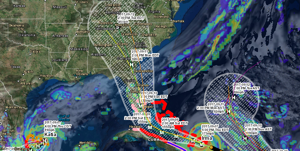
Irma is moving toward the west-northwest near 16 mph, and this general motion is expected to continue for the next couple of days with some decrease in forward speed. On the forecast track, the eye of Irma should continue to move near the Turks and Caicos Islands and toward the southeastern Bahamas this evening. The core of the hurricane will then move between the north coast of Cuba and the Bahamas during the next day or two.
Maximum sustained winds remain near 175 mph with higher gusts. Irma is a category 5 hurricane on the Saffir-Simpson
Hurricane Wind Scale. Some fluctuations in intensity are likely during the next day or two, but Irma is forecast to remain a powerful category 4 or 5 hurricane during the next couple of days.
Hurricane-force winds extend outward up to 70 miles from the center, and tropical-storm-force winds extend outward up to 185 miles.
HAZARDS AFFECTING LAND
STORM SURGE:
- Jupiter Inlet to Bonita Beach, including Florida Keys…5 to 10 ft
- Turks and Caicos Islands…15 to 20 ft
- Southeastern and central Bahamas…15 to 20 ft
- Northwestern Bahamas…5 to 10 ft
- Northern coast of the Dominican Republic…3 to 5 ft
- Northern coast of Haiti and the Gulf of Gonave…1 to 3 ft
- Northern coast of Cuba in the warning area…5 to 10 ft
WIND:
Hurricane conditions are expected to continue within the hurricane warning area in the Dominican Republic and Haiti tonight.
Hurricane conditions are occurring on the Turks and Caicos Islands. Tropical storm and hurricane conditions are beginning in the southeastern Bahamas and will spread into the central Bahamas by tonight or early Friday. Hurricane conditions are expected within the hurricane warning area along the north coast of Cuba late Friday and Saturday. Hurricane conditions are expected in the northwestern Bahamas Friday night and Saturday. Hurricane conditions are possible within the watch area in Florida by Sunday, with tropical storm conditions possible by late Saturday.
RAINFALL: (Irma is expected to produce the following rain accumulations through Saturday evening)
- Northeast Puerto Rico and the British and U.S. Virgin Islands… additional 1 to 2 inches
- Much of the Bahamas and Turks and Caicos…8 to 12 inches, isolated 20 inches
- Andros Island and Bimini, Bahamas…12 to 16 inches, isolated 25 inches
- Northern Dominican Republic and northern Haiti…4 to 10 inches, isolated 15 inches
- Southern Dominican Republic and southern Haiti…2 to 5 inches
- Eastern and central Cuba…4 to 10 inches, isolated 15 inches
- Southeast Florida and the upper Florida Keys…8 to 12 inches, isolated 20 inches
- Lower Florida Keys…2 to 5 inches
SURF:
Swells generated by Irma are affecting Puerto Rico, the
Virgin Islands, the southeastern Bahamas, the Turks and Caicos
Islands, the northern coast of the Dominican Republic, and should
start affecting portions of the southeast coast of the United States
later today and tonight. These swells are likely to cause
life-threatening surf and rip current conditions.
Information and Data courtesy of the National Weather Service.
Thanks for making SevereWXWarn your #1 source for severe weather! We will continue to provide daily updates on Irma, so be sure to like us on Facebook and download our mobile apps of your phone or tablet.
Like Us on Facebook
Download Our Hurricane Tracker On Apple
Download Our Hurricane Tracker On Android
Download Our Storm Tracker On Apple
Download our Storm Tracker On Android