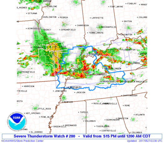

WW 280 SEVERE TSTM IL IN KY MO TN 272215Z – 280500Z

URGENT - IMMEDIATE BROADCAST REQUESTED
Severe Thunderstorm Watch Number 280
NWS Storm Prediction Center Norman OK
515 PM CDT Sat May 27 2017

The NWS Storm Prediction Center has issued a

* Severe Thunderstorm Watch for portions of
  Southern Illinois
  Southwest Indiana
  Western and south-central Kentucky
  Far southeast Missouri
  Western and middle Tennessee

* Effective this Saturday afternoon from 515 PM until Midnight
  CDT.

...THIS IS A PARTICULARLY DANGEROUS SITUATION...

* Primary threats include...
  Widespread damaging winds expected with scattered significant
    gusts to 80 mph likely
  Scattered large hail and isolated very large hail events to 2
    inches in diameter possible
  A few tornadoes possible

SUMMARY...A very fast-moving line of convection will continue to
pose a risk for widespread wind damage as it races
east-southeastward through the evening hours. A few tornadoes and
hail will also be possible with the fast-moving squall line and/or
other line-preceding storms.

The severe thunderstorm watch area is approximately along and 70
statute miles north and south of a line from 30 miles west northwest
of Cape Girardeau MO to 55 miles east southeast of Bowling Green KY.
For a complete depiction of the watch see the associated watch
outline update (WOUS64 KWNS WOU0).

PRECAUTIONARY/PREPAREDNESS ACTIONS...

REMEMBER...A Severe Thunderstorm Watch means conditions are
favorable for severe thunderstorms in and close to the watch area.
Persons in these areas should be on the lookout for threatening
weather conditions and listen for later statements and possible
warnings. Severe thunderstorms can and occasionally do produce
tornadoes.

&&

OTHER WATCH INFORMATION...CONTINUE...WW 275...WW 276...WW
277...WW 278...WW 279...

AVIATION...A few severe thunderstorms with hail surface and aloft to
2 inches. Extreme turbulence and surface wind gusts to 70 knots. A
few cumulonimbi with maximum tops to 600. Mean storm motion vector
29045.

...Guyer
Read more
Source: SPC