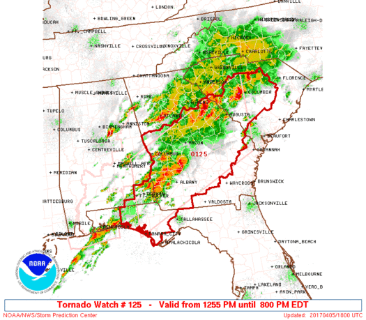
WW 125 TORNADO AL FL GA SC 051655Z – 060000Z
URGENT - IMMEDIATE BROADCAST REQUESTED
Tornado Watch Number 125
NWS Storm Prediction Center Norman OK
1255 PM EDT Wed Apr 5 2017

The NWS Storm Prediction Center has issued a

* Tornado Watch for portions of
  Southeast Alabama
  Florida Panhandle
  Central and Southwest Georgia
  Western South Carolina

* Effective this Wednesday afternoon and evening from 1255 PM
  until 800 PM EDT.

...THIS IS A PARTICULARLY DANGEROUS SITUATION...

* Primary threats include...
  Numerous tornadoes expected with a few intense tornadoes likely
  Widespread large hail and isolated very large hail events to 2.5
    inches in diameter likely
  Widespread damaging winds likely with isolated significant gusts
    to 75 mph possible

SUMMARY...Intense supercell thunderstorms are expected to develop
this afternoon over the watch area, posing a risk of strong
tornadoes.  Large hail and damaging winds are possible as well.

The tornado watch area is approximately along and 85 statute miles
north and south of a line from 20 miles west southwest of Dothan AL
to 45 miles east of Augusta GA. For a complete depiction of the
watch see the associated watch outline update (WOUS64 KWNS WOU5).

PRECAUTIONARY/PREPAREDNESS ACTIONS...

REMEMBER...A Tornado Watch means conditions are favorable for
tornadoes and severe thunderstorms in and close to the watch
area. Persons in these areas should be on the lookout for
threatening weather conditions and listen for later statements
and possible warnings.

&&

OTHER WATCH INFORMATION...CONTINUE...WW 124...

AVIATION...Tornadoes and a few severe thunderstorms with hail
surface and aloft to 2.5 inches. Extreme turbulence and surface wind
gusts to 65 knots. A few cumulonimbi with maximum tops to 500. Mean
storm motion vector 24035.

...Hart
Read more
Source: SPC