
WW 317 TORNADO CO NE WY 121910Z – 130200Z

URGENT - IMMEDIATE BROADCAST REQUESTED
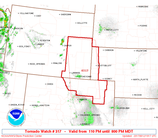
Tornado Watch Number 317
NWS Storm Prediction Center Norman OK
110 PM MDT Mon Jun 12 2017
The NWS Storm Prediction Center has issued a
* Tornado Watch for portions of
Northeast Colorado
Western Nebraska Panhandle
Southeast Wyoming
* Effective this Monday afternoon and evening from 110 PM until
800 PM MDT.
...THIS IS A PARTICULARLY DANGEROUS SITUATION...
* Primary threats include...
Several tornadoes and a few intense tornadoes likely
Widespread large hail expected with scattered very large hail
events to 4 inches in diameter likely
Isolated significant damaging wind gusts to 75 mph possible
SUMMARY...Isolated intense supercell thunderstorms are expected to
develop across the watch area this afternoon. Giant hail and strong
tornadoes will be possible in the most intense storms.
The tornado watch area is approximately along and 60 statute miles
east and west of a line from 50 miles north northeast of Douglas WY
to 55 miles southeast of Fort Collins CO. For a complete depiction
of the watch see the associated watch outline update (WOUS64 KWNS
WOU7).
PRECAUTIONARY/PREPAREDNESS ACTIONS...
REMEMBER...A Tornado Watch means conditions are favorable for
tornadoes and severe thunderstorms in and close to the watch
area. Persons in these areas should be on the lookout for
threatening weather conditions and listen for later statements
and possible warnings.
&&
OTHER WATCH INFORMATION...CONTINUE...WW 316...
AVIATION...Tornadoes and a few severe thunderstorms with hail
surface and aloft to 4 inches. Extreme turbulence and surface wind
gusts to 65 knots. A few cumulonimbi with maximum tops to 500. Mean
storm motion vector 24030.
...Hart
Read more
Source: SPC