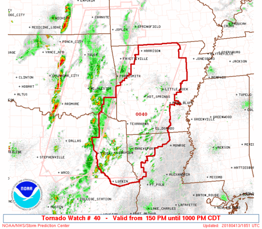
WW 40 TORNADO AR LA OK TX 131850Z – 140300Z
URGENT - IMMEDIATE BROADCAST REQUESTED
Tornado Watch Number 40
NWS Storm Prediction Center Norman OK
150 PM CDT Fri Apr 13 2018

The NWS Storm Prediction Center has issued a

* Tornado Watch for portions of
  Much of Arkansas
  Northwest Louisiana
  Southeast Oklahoma
  Northeast Texas

* Effective this Friday afternoon and evening from 150 PM until
  1000 PM CDT.

...THIS IS A PARTICULARLY DANGEROUS SITUATION...

* Primary threats include...
  Numerous tornadoes expected with a few intense tornadoes likely
  Widespread large hail and isolated very large hail events to 2.5
    inches in diameter likely
  Widespread damaging wind gusts to 70 mph likely

SUMMARY...Intense thunderstorms are expected to track across the
watch area this afternoon and early evening, posing a risk of
tornadoes, large hail and damaging winds.  Strong tornadoes are
possible.  Multiple rounds of severe storms are expected across this
region.

The tornado watch area is approximately along and 70 statute miles
east and west of a line from 70 miles south of Longview TX to 20
miles northeast of Flippin AR. For a complete depiction of the watch
see the associated watch outline update (WOUS64 KWNS WOU0).

PRECAUTIONARY/PREPAREDNESS ACTIONS...

REMEMBER...A Tornado Watch means conditions are favorable for
tornadoes and severe thunderstorms in and close to the watch
area. Persons in these areas should be on the lookout for
threatening weather conditions and listen for later statements
and possible warnings.

&&

OTHER WATCH INFORMATION...CONTINUE...WW 39...

AVIATION...Tornadoes and a few severe thunderstorms with hail
surface and aloft to 2.5 inches. Extreme turbulence and surface wind
gusts to 60 knots. A few cumulonimbi with maximum tops to 500. Mean
storm motion vector 24035.

...Hart
Read more
Source: SPC