…SUMMARY… Severe thunderstorms may produce damaging gusts, a few tornadoes (possibly strong), and isolated large hail today across the lower Mississippi Valley through the central Gulf Coast region.
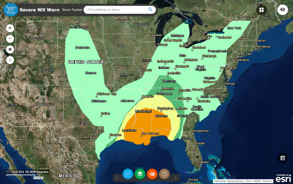
…Synopsis… In mid/upper levels, a synoptic-scale trough will proceed from MN and the central/southern Plains to the Upper Great Lakes and lower/mid Mississippi Valley through the period. The two most important associated smaller-scale perturbations for convective purposes will be: 1. An initially strong, basal shortwave trough — now evident in moisture-channel imagery over western/central OK and west-central TX. This feature is forecast to pivot eastward then northeastward while losing amplitude, and to reach portions of AR, northern LA and southeast TX by 00Z. This feature will eject northeastward toward the Ohio Valley and weaken markedly overnight. 2. An upstream trough and associated speed max in northwesterly flow — currently apparent over the northern High Plains. Its leading portion will dig southeastward across KS/OK by 00Z, then become the new strong/basal shortwave trough over LA by 12Z. At the surface, beneath height falls related to the features aloft, a surface low should form along a cold front over northeast TX or the Arklatex region and shift erratically to the Mid-South region by 00Z, perhaps catching up to the preconvective warm sector this afternoon. The cold front was analyzed at 11Z in a convectively modified air mass across the MO/northwest AR Ozarks, southeastern OK, north-central TX, to near DRT. The leading convective/outflow boundary extended from southeastern AR across northwestern LA and extreme southeast TX. By 00Z the cold front should reach western portions of TN/MS and southeastern/south-central LA. The low should deepen considerably overnight and move across central/northeastern KY. By 12Z the front should reach eastern TN, the GA/AL border vicinity, and western FL Panhandle. A marine/warm front was drawn at 11Z over western FL Panhandle coastal waters to near the MS/AL coastlines, then inland across southeastern to northern LA. This boundary, which denoted the northern rim of the best-modified, richly moist Gulf air mass, should become gradually more diffuse, and move east-northeastward across portions of southern/central MS through the afternoon. This evening and overnight, it should cross southern AL and western FL Panhandle. …Lower Mississippi Valley, Gulf Coast States… Scattered to numerous thunderstorms are expected to cross the area through the period, generally from west to east in the form of a quasi-linear convective system (QLCS), but with some warm-sector supercells also possible. Damaging winds and a few tornadoes (possibly strong) are expected, and isolated hail is possible as well. As the shortwave perturbation rounds the base of the broader-scale trough and the surface low strengthens, low-level isallobaric/mass response will contribute to backed warm-sector flow across the Central Gulf Coast and Delta regions, in addition to the backing and low-level vorticity enhancement expected along the warm/marine front. These factors will contribute to a 50-65-kt LLJ atop favorably large low-level hodographs (i.e., effective SRH 300-500 J/kg) and a CAPE/shear parameter space ordinarily well within ranges typically associated with significant tornadoes. Forecast soundings show a combination of boundary-layer theta-e advection and muted diurnal heating helping to boost MLCAPE into the 1000-1500 J/kg range near and south of the inland-penetrating marine front. Strengthening southwesterly mean-wind/deep-shear vectors will spread over the outlook area today into this evening. The QLCS largely responsible for the enhanced damaging-wind threat, beneath that strong flow, may arise from an increasingly organized band of convection now located over the Gulf — south of a nearshore outflow boundary, east of CRP, and southwest of GLS. A modulating influence, however, may be storm mode. The bulk of convection should be quasi-linear, with only conditional potential of warm-sector supercells surviving long enough to become tornadic in that favorable environment before being overtaken by the MCS. QLCS tornadoes (which occasionally can become significant also, though not to the frequency and duration of supercellular ones) also are possible as the convective band impinges on the high-SRH and marginally to moderately unstable boundary layer. For now, will maintain the significant-tornado area with some peripheral modifications. …South-central Plains… Isolated to widely scattered thunderstorms are possible mainly this afternoon, as diabatic heating of the boundary layer removes MLCINH beneath very cold air aloft. Hail and gusts approaching severe limits are expected in the most intense cells. Even with surface temperatures only in the mid/upper 60s F, modified forecast soundings show some favorable conditions: -20 to -24 C 500-mb temperatures, lapse rates 7-8 deg C/km from surface-500 mb, and enough residual low-level moisture to support 500-800 J/kg of uncapped MLCAPE. Buoyancy also should extend into icing layers suitable for production of both lightning and at least small hail. Additionally, well-mixed subcloud layers with almost dry-adiabatic 0-3-km lapse rates may enable gusts approaching severe limits. A general-thunder area is being added with this outlook package. If confidence increases in large hail and severe gusts, severe probabilities may be added in a succeeding update.
