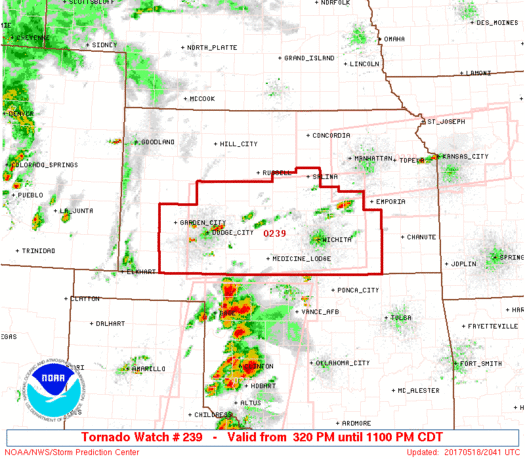

WW 239 TORNADO KS 182020Z – 190400Z

URGENT - IMMEDIATE BROADCAST REQUESTED
Tornado Watch Number 239...CORRECTED
NWS Storm Prediction Center Norman OK
330 PM CDT Thu May 18 2017

CORRECTED TO INCLUDE PDS WORDING

The NWS Storm Prediction Center has issued a

* Tornado Watch for portions of
  PORTIONS OF central and southern Kansas
* Effective this Thursday afternoon and evening from 330 PM until
  1100 PM CDT.

...THIS IS A PARTICULARLY DANGEROUS SITUATION...

* Primary threats include...
  Several tornadoes and a few intense tornadoes likely
  Scattered large hail and isolated very large hail events to 4
    inches in diameter possible
  Scattered damaging wind gusts to 70 mph possible

SUMMARY...Thunderstorms are forecast to develop across/spread into
southern portions of Kansas over the next 1-2 hours, with attendant
increase in significant severe risk -- including very
large/destructive hail, damaging winds, and the potential for
several strong tornadoes.

The tornado watch area is approximately along and 60 statute miles
north and south of a line from 25 miles west of Dodge City KS to 65
miles east northeast of Wichita KS. For a complete depiction of the
watch see the associated watch outline update (WOUS64 KWNS WOU9).

PRECAUTIONARY/PREPAREDNESS ACTIONS...

REMEMBER...A Tornado Watch means conditions are favorable for
tornadoes and severe thunderstorms in and close to the watch
area. Persons in these areas should be on the lookout for
threatening weather conditions and listen for later statements
and possible warnings.

&&

OTHER WATCH INFORMATION...CONTINUE...WW 235...WW 236...WW
237...WW 238...

AVIATION...Tornadoes and a few severe thunderstorms with hail
surface and aloft to 4 inches. Extreme turbulence and surface wind
gusts to 60 knots. A few cumulonimbi with maximum tops to 500. Mean
storm motion vector 24035.

...Goss
Read more
Source: SPC