
WW 42 TORNADO IA IL IN MO LM 282100Z – 010400Z

URGENT - IMMEDIATE BROADCAST REQUESTED
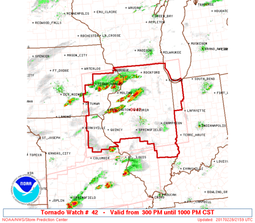
Tornado Watch Number 42
NWS Storm Prediction Center Norman OK
300 PM CST Tue Feb 28 2017
The NWS Storm Prediction Center has issued a
* Tornado Watch for portions of
Southeast Iowa
Northern and Central Illinois
Northwest Indiana
Northeast Missouri
Lake Michigan
* Effective this Tuesday afternoon and evening from 300 PM until
1000 PM CST.
* Primary threats include...
A few tornadoes possible
Scattered large hail likely with isolated very large hail events
to 3 inches in diameter possible
Scattered damaging wind gusts to 70 mph possible
SUMMARY...Scattered thunderstorms are expected to form this
afternoon and early evening across the watch area. Conditions
appear favorable for large hail in the stronger cells, along with
the risk for isolated tornadoes.
The tornado watch area is approximately along and 120 statute miles
north and south of a line from 35 miles south of Ottumwa IA to 30
miles north of Lafayette IN. For a complete depiction of the watch
see the associated watch outline update (WOUS64 KWNS WOU2).
PRECAUTIONARY/PREPAREDNESS ACTIONS...
REMEMBER...A Tornado Watch means conditions are favorable for
tornadoes and severe thunderstorms in and close to the watch
area. Persons in these areas should be on the lookout for
threatening weather conditions and listen for later statements
and possible warnings.
&&
OTHER WATCH INFORMATION...CONTINUE...WW 41...
AVIATION...Tornadoes and a few severe thunderstorms with hail
surface and aloft to 3 inches. Extreme turbulence and surface wind
gusts to 60 knots. A few cumulonimbi with maximum tops to 450. Mean
storm motion vector 25035.
...Hart
Read more
Source: Severe/Tornado Watches

