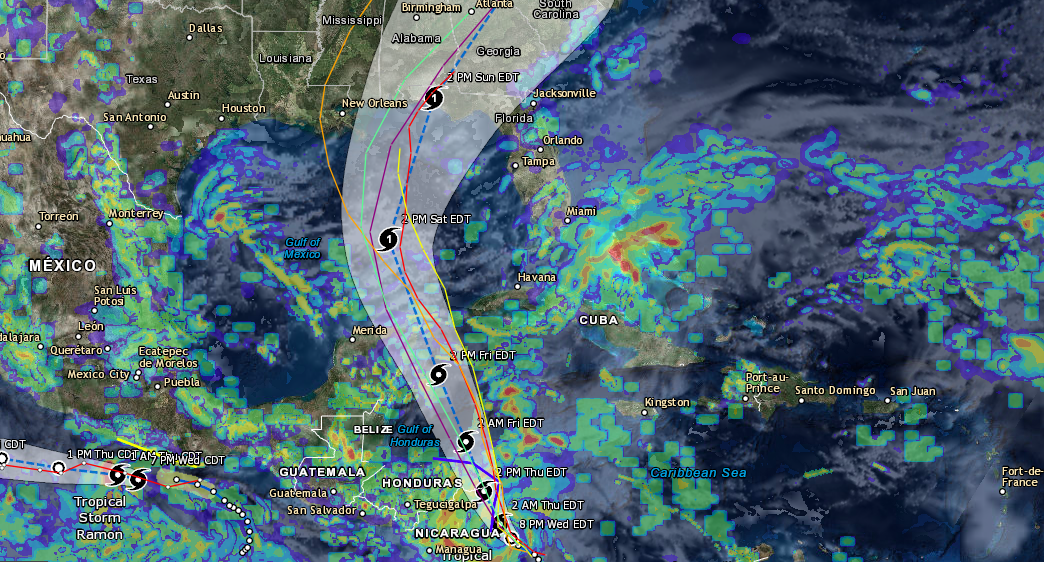
Tropical Storm Joaquin will likely become a hurricane on Wednesday as the storm continues to intensify quickly. The winds in the storm are currently near 60 mph. This storm rapidly intensified on Tuesday as thunderstorm activity has beefed up in the storm especially on the southeast corner where rainfall is coming down at over 2 inches per hour. The system all together looks much more organized as a whole. The current path of this storm is unknown as the deciding factors for this storm have continually changed and none of the models seem to be in agreeance at the moment. Some of the models are pushing this storm out to sea and others are pushing it closer in towards the east coast of the US. This storm will need to be monitored closely by anyone living on the eastern coast of the US this week as this could be a threat to some coastal regions by as early as next week. Of the all the models that we study only 2 on the models are agreeing on a landfall location at the moment. We will continually be monitoring this system over the coming days and will likely have a better idea of where this storm is going and what impacts it will bring with it. The models are all in agreeance that this system will develop into a hurricane so that is one thing that we are pretty sure of. Please be sure to like us on Facebook and share our post with you family and friends on social media using the buttons above. Also be sure to check out the free resources we have available on our site for tracking severe weather. We will post updates on this system as they change. Be sure to check back to our news feed often as well as our Facebook page.