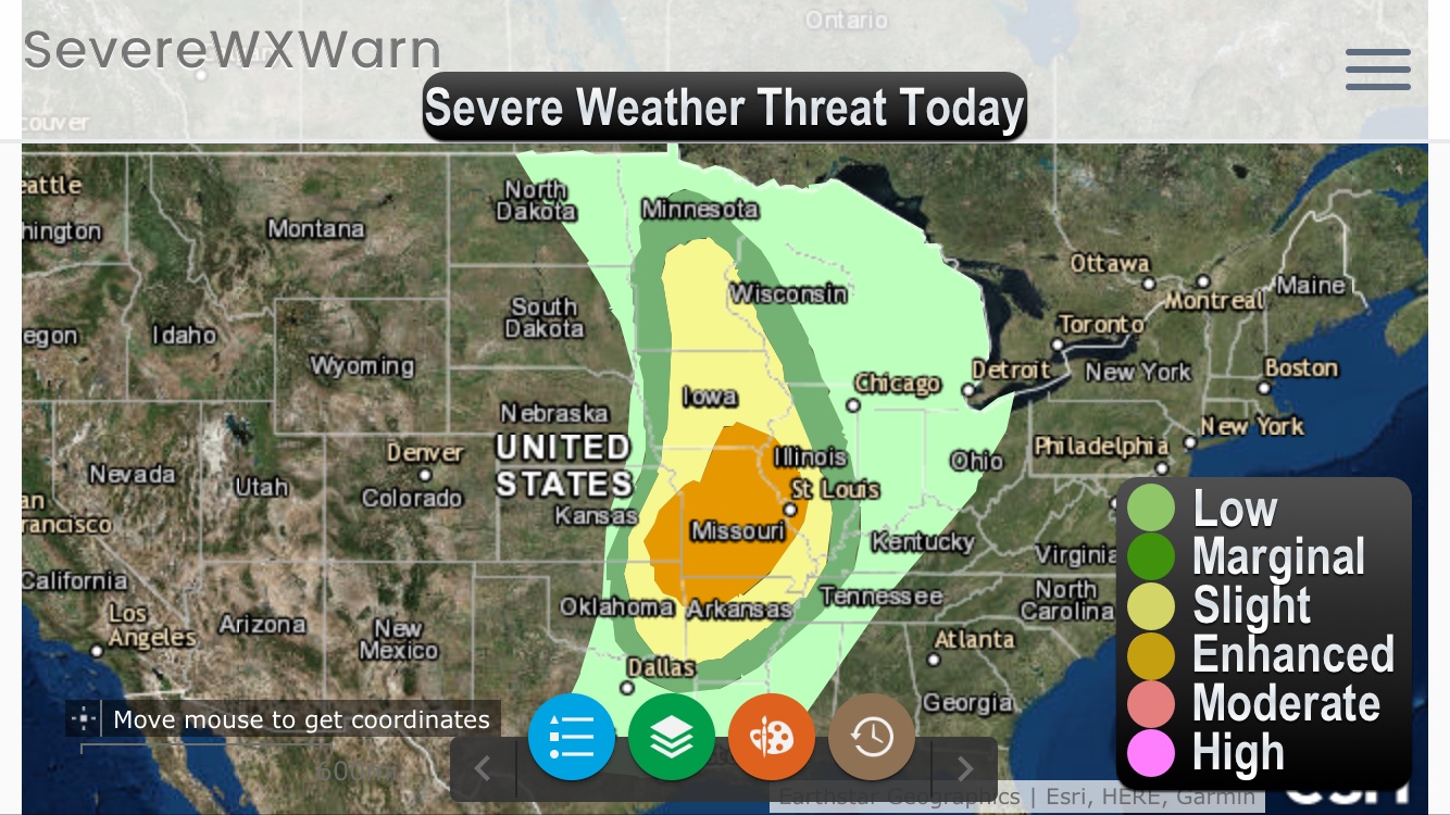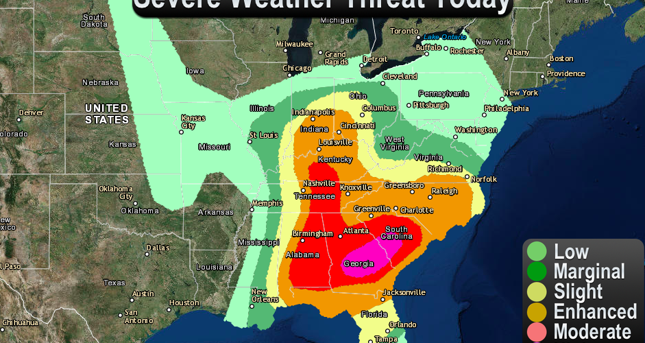
An outbreak of severe thunderstorms is expected from portions of the
Southeast States to the Ohio Valley region and eastward to the
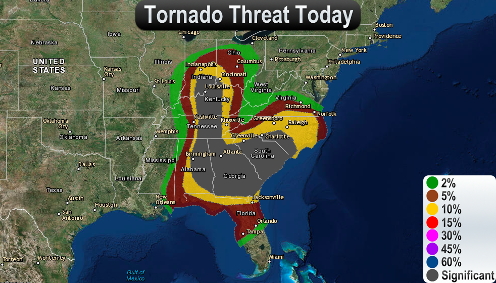
Mid-Atlantic. Significant tornadoes will be possible, especially
from parts of central and southern Georgia into South Carolina, and
also from parts of eastern Alabama into south-central Kentucky. In
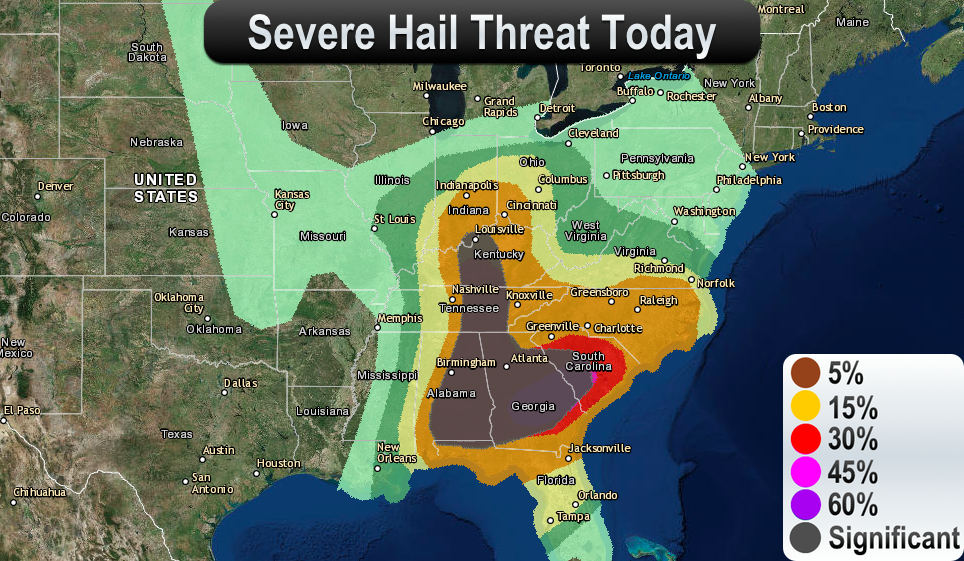
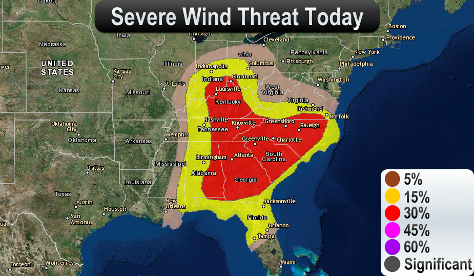
addition, very large hail, and damaging wind gusts are expected.
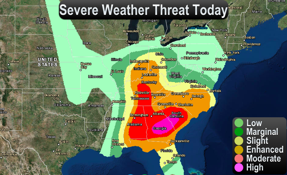
HIGH RISK
-CENTRAL AND SOUTHERN GEORGIA INTO CENTRAL SOUTH CAROLINA.
MODERATE RISK
-PORTIONS OF SOUTH CAROLINA TO GEORGIA AND ALABAMA AND THEN
NORTHWARD INTO SOUTH-CENTRAL KENTUCKY.
ENHANCED RISK
-PORTIONS OF THE OHIO VALLEY REGION TO THE SOUTHEAST
STATES AND MID-ATLANTIC.
SLIGHT RISK
-PORTIONS OF THE LOWER GREAT LAKES REGION TO THE
SOUTHEAST STATES AND MID-ATLANTIC.
Download our Storm Tracker on Android – Click Here to Download
Download our Storm Tracker on Apple Devices – Click Here to Download
View our Storm Tracker on our Website – Click Here to View
Portions of the Southeast States to the Ohio Valley region and
the Mid-Atlantic
Ongoing semi-discrete supercells and supercell clusters are
developing northeastward from parts of the central/eastern Gulf
Coast into southern GA. This activity resides well ahead of a
shortwave trough across the South-Central States and is evolving
within a broad, moistening open warm sector. With observational data
suggesting dewpoints in the lower 70s developing northward ahead of
this activity, supporting MLCAPE around 2000-3000 J/kg aided by
warm-sector insolation steepening low-level lapse rates beneath a
residual EML plume, and given the ongoing semi-discrete nature to
rotating updrafts developing as far south as the central Gulf Coast
vicinity, there is increasing confidence that long-track supercells
will be likely. Furthermore, with maturing midlevel mesocyclones
already evident, and low-level SRH around 200-300 m2/s2 aiding the
development of low-level mesocyclones amid the increasing low-level
theta-e, confidence has increased in higher coverage of tornado
potential — including significant tornado potential — across the
now-upgraded High Risk area. This activity will spread across the
High Risk area into the evening hours, as vertical wind profiles
further strengthen with the approaching midlevel trough and 700-mb
flow increasing over 50 kt. Observational trends and previous model
guidance are the primary supporters of this High Risk upgrade, as
opposed to the most recent model guidance which suggests a dry bias
in thermodynamic profiles — Reference Mesoscale Discussion 440.
Outflow from ongoing convection from north GA to western SC serves
as a northern bound to the greatest severe potential.
Furthermore, confidence has increased that substantial severe risk
including tornado potential will develop through parts of the
Mid-Atlantic region into the overnight hours amid strong low-level
and deep shear, and a moistening boundary layer. As a result, severe
probabilities have been increased across parts of the Mid-Atlantic.
Also, severe storms are expected to spread across parts of the Gulf
Coast vicinity into the evening/overnight hours — affecting parts
of north/central FL with tornado potential.
Farther to the west, a somewhat separate area of severe storm
development will be likely from parts of the Ohio Valley region to
the Tennessee Valley and vicinity in association with the primary
midlevel vorticity maximum and related low-level baroclinic zone
this afternoon. Strong low-level SRH in the destabilizing warm
sector — enhanced near the surface low tracking from parts of IL
into OH — will support organized, rotating updrafts. All severe
hazards — including significant hail and tornadoes — will be
possible from this afternoon into the evening.
Source: Storm Prediction Center (NWS)