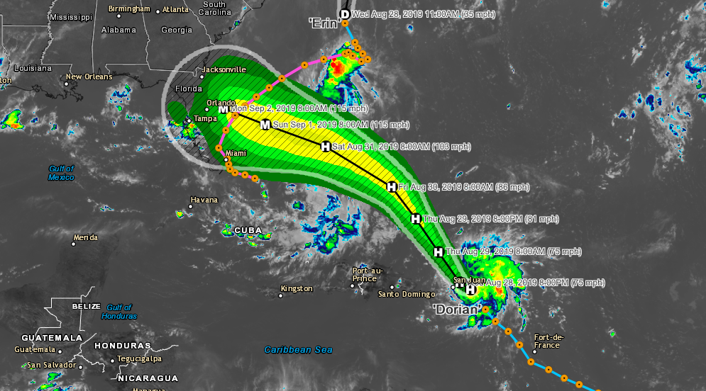
Dorian is now a hurricane located near St Thomas. Maximum sustained winds are currently 75 MPH with a central pressure of 997 MB. The storm is moving northwest at 13 MPH with this motion expected for the next couple days. Hurricane warnings have been issued for Vieques, Culebra, US Virgin Islands and British Virgin Islands. A hurricane watch and tropical storm warning is also in effect for Puerto Rico. A Hurricane Warning means that hurricane conditions are expected somewhere within the warning area, in this case within the next 6 to 12 hours. A Hurricane Watch means that hurricane conditions are possible within the watch area, in this case within the next 6 to 12 hours. On this track, Dorian should continue to move near or over the U.S. and British Virgin Islands this afternoon and then move over the open Atlantic well east of the southeastern Bahamas. Dorian is forecast to continue strengthening during the next few days over the Atlantic waters. Hurricane-force winds extend outward up to 20 miles to the north and east of the center. Tropical-storm-force winds extend outward up to 80 miles primarily to the east of the center. An elevated weather station on Buck Island just south of St. Thomas reported a sustained wind of 82 mph and a gust of 111 mph

EXPECTED RAINFALL
Northern Leeward Islands - 1 to 3 inches.
Eastern Puerto Rico, the Virgin Islands - 4 to 6 inches, isolated 10 inches
northwest Bahamas - 4 to 6 inches, isolated 10 inches
Western Puerto Rico and the central Bahamas - 2 to 4 inches
Coastal sections of the Southeast United States - 4 to 8 inches, isolated 10 inches.


