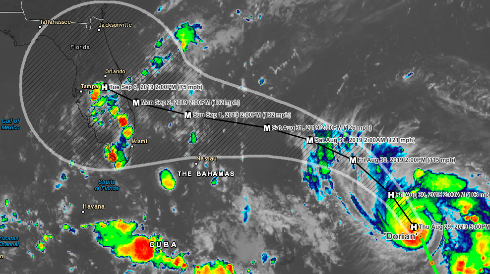
Hurricane Dorian is now located about 300 miles east of the Bahamas with max winds of 85 MPH moving northwest at 13 MPH. The storm is expected to strengthen over the coming days and and is expected to become a major hurricane on Saturday and could possibly be a category 4 storm at landfall on Monday or Tuesday of next week. Those in the Bahamas and Florida should start preparing now. Even if you are in Georgia or the Carolina's you should prepare as a precaution and have a plan in place. The Bahamas could see rain amounts of 2-5 inches with isolated amounts of 6-7 inches. The southeastern US could see 5-10 inches with isolated amounts of over 15 inches.

from the NHC:
The hurricane should continue moving northwestward tonight between an upper-level low just to the west of Dorian and a mid-level ridge near Bermuda. On Friday, the ridge is forecast to begin building westward to the north of the cyclone, and this pattern is expected to cause the hurricane to turn west-northwestward.  A west-northwestward to westward motion should then continue into the weekend with Dorian moving near or over the northwestern Bahamas and toward the Florida peninsula.  The guidance envelope has nudged southward this cycle, with the ECMWF and HMON along the southern side, and the GFS bracketing the northern side.  There has also been an increase in along-track spread or speed differences with day 5 positions among the dynamical models ranging from near the northwestern Bahamas to the northeastern Gulf of Mexico.  This appears to be the result of differences in the models' depiction of the strength or lack thereof of the western portion of the ridge by day 5.  The new NHC track forecast is essentially unchanged through the first 2 to 3 days, but has been adjusted southward and somewhat slower than the previous advisory at 96 and 120 hours.  Users are reminded to not focus on the exact forecast track, as typical forecast errors at days 4 and 5 are around 155 and 205 miles, respectively. The new intensity forecast is unchanged from the previous one. Dorian will be moving through a favorable environment of low vertical wind shear and warm sea surface temperatures.  This should allow for at least steady intensification, and Dorian is forecast to become major hurricane on Friday.  Dorian is predicted to remain a dangerous hurricane throughout the remainder of the forecast period. The NHC intensity forecast is again near the upper end of the guidance in best agreement with the HWRF and FSSE models.