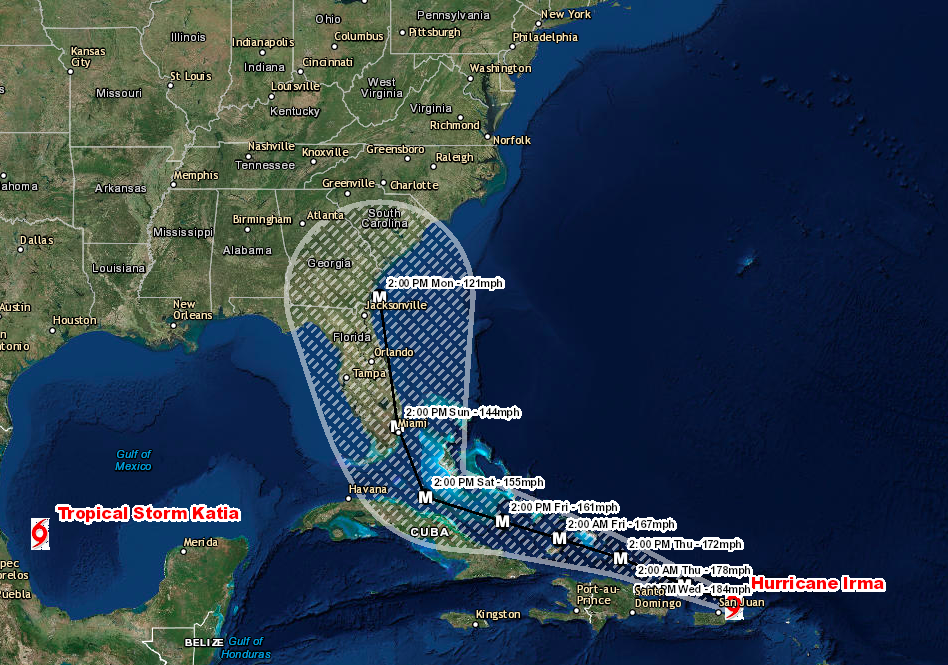
We have been continually monitoring Hurricane Irma now for the past week and is now likely 4 days away from a direct impact on the United States. The current track would consist of the storm making landfall briefly in Florida on Sunday afternoon with the possibility of a second landfall near the South Carolina/Georgia border on Monday. Irma is expected to remain a Major Hurricane through Monday depending on the exact track.Irma is moving toward the west northwest near 16 mph (26 km/h), and this general motion is expected to continue for the next couple of days. On the forecast track, the extremely dangerous core of Irma will pass just north of Puerto Rico tonight, pass near or just north of the coast of Hispaniola Thursday, and be near the Turks and Caicos and southeastern Bahamas by Thursday evening. Maximum sustained winds are near 185 mph (295 km/h) with higher gusts. Irma is a category 5 hurricane on the Saffir-Simpson Hurricane Wind Scale. Some fluctuations in intensity are likely during the next day or two, but Irma is forecast to remain a powerful category 4 or 5 hurricane during the next couple of days. Hurricane-force winds extend outward up to 50 miles (85 km) from the center and tropical-storm-force winds extend outward up to 185 miles.
Storm Surge Expected:
Turks and Caicos Islands…15 to 20 ft
Southeastern and central Bahamas…15 to 20 ft
Northern coast of the Dominican Republic…3 to 5 ft
Northern coast of Haiti and the Gulf of Gonave…1 to 3 ft
Northern coast of Cuba in the warning area…5 to 10 ft
Rainfall Expected
Northern Leeward Islands…Additional 1 to 3 inches. Storm total 8
to 12 inches, isolated 20 inches.
Northeast Puerto Rico and the British and U.S. Virgin Islands…6 to
12 inches, isolated 20 inches.
Southwest Puerto Rico…3 to 6 inches, isolated 10 inches.
The Southern Leeward Islands, and Saint Croix…2 to 4 inches.
Southeast Bahamas, Central Bahamas, and the Turks and Caicos…8 to
12 inches, isolated 20 inches.
Northern Dominican Republic and northern Haiti…4 to 10 inches,
isolated 15 inches.
Eastern and Central Cuba…4 to 10 inches, isolated 15 inches.
Southwest Haiti…1 to 4 inches.
Hurricane Irma (6:00 PM AST Wed Sep 6)
Location: 18.9°N 65.6°W
Moving: WNW at 16 mph
Min pressure: 914 mb
Max sustained: 185 mph
Like Us on Facebook
Download Our Hurricane Tracker On Apple
Download Our Hurricane Tracker On Android
Download Our Storm Tracker On Apple
Download our Storm Tracker On Android