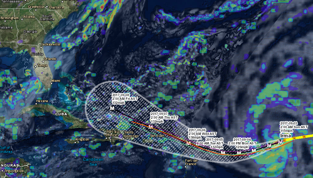
Tropical Storm Erika developed overnight and currently has winds of 40 mph with gusts to 50 mph. Erika is expected to strengthen into the second hurricane of the 2015 Atlantic season by Saturday and will likely be a threat to the Bahamas on Sunday. As of now it looks like Erika could possibly make landfall on the U.S. east coast sometime between Sunday and Tuesday, but it is to far out to be sure and to know exactly where the storm could affect. The hurricane models are all pretty much in agreeance with developing this storm and putting it in the area just off the coast of Miami sometime Sunday. Since this is still 5-7 days away we will have a better idea of what this storm will do in the next couple of days as the storm approaches. If you are on the east coast of the United States be sure that you are prepared just in case this storms comes your way. We will be providing updates on this storm 2-3 times daily and even more as the storm approaches so be sure to like us on Facebook and check back with us often. We offer tons of free maps and information to keep you safe and weather aware. Below is some information on Erika as well as some maps and data. Please share this post with your friends using the social media share links above. We will provide the next update at 6 p.m.
Click Here For The Most Recent Information
Location: 14.5°N 48.6°W
Maximum Winds: 40 kt Gusts: 50 kt
Minimum Central Pressure: 1003 mb
Environmental Pressure: 1012 mb
Radius of Circulation: 240 NM
Radius of Maximum Wind: 50 NM