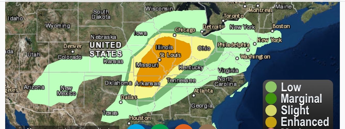
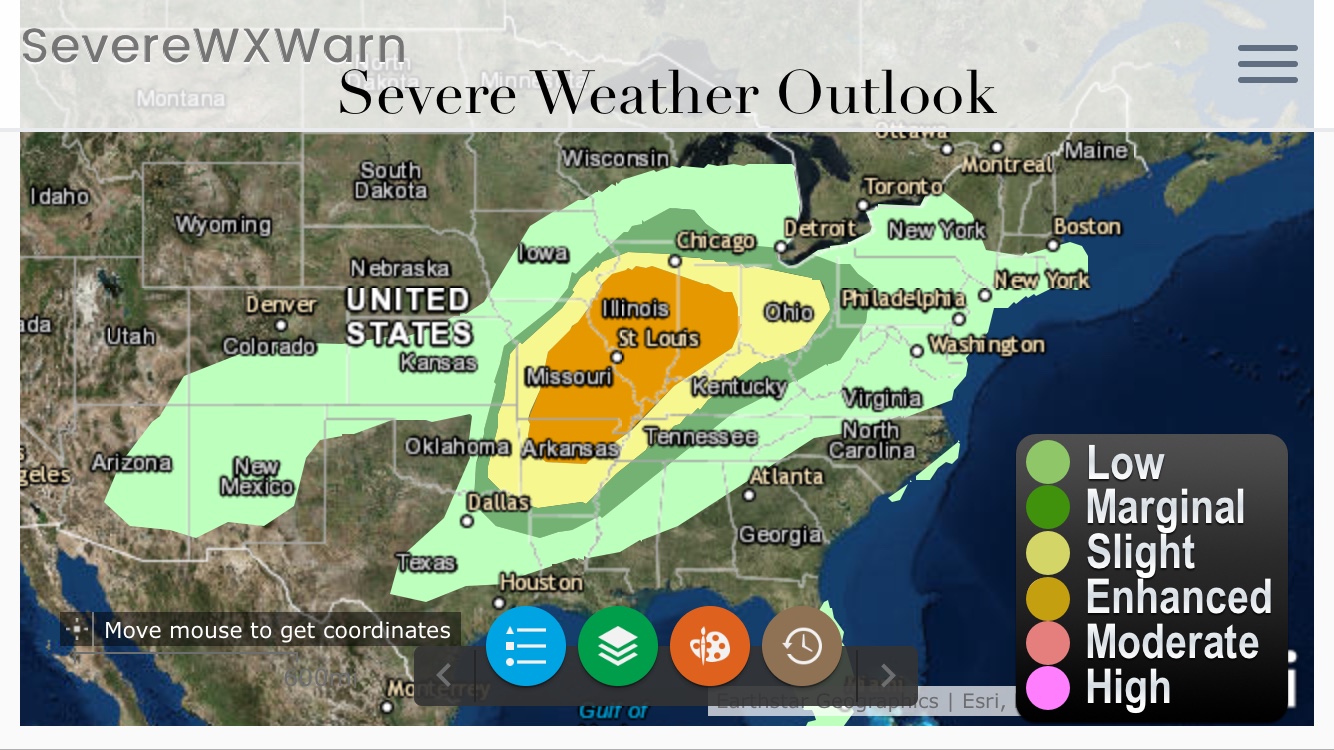
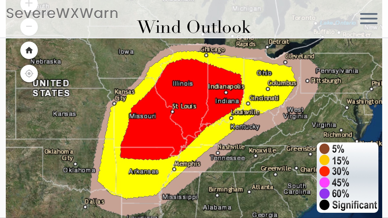
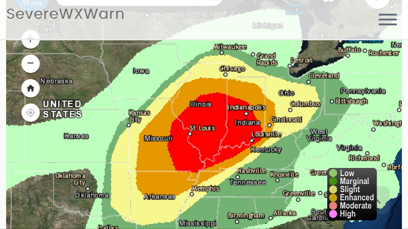
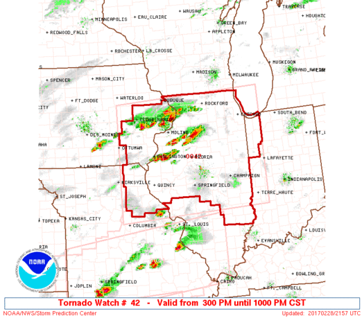
An enhanced severe weather outlook is in effect today for areas from northern Arkansas northeastward across parts of Missouri, Illinois and Indiana. A slight risk of severe weather extends from Texas into the Ohio Valley. The main threat for severe weather will be this afternoon into the late evening hours with the main threats being straight line winds and hail with the possibility of some strong tornadoes. Below is the information directly from the Storm Prediction Center on the current situation. Be sure to check out the features offered on our site to track the severe weather and stay ahead of the storms.
…SUMMARY… (Courtesy: Storm Prediction Center – National Weather Service)
Severe thunderstorms are expected to develop from portions of the
lower Mississippi Valley to the Ohio Valley through tonight. Large
hail, damaging winds, and a few strong tornadoes are possible.
…Synopsis…
A large-scale mid-upper trough over the Great Basin and lower CO
River valley will progress eastward to the MS Valley by the end of
the period. An associated surface cyclone will develop
northeastward from the MO/IA border to Lower MI overnight, as a cold
front moves eastward from the Plains to the MS Valley. Ahead of the
front, a relatively broad/unstable warm sector is expected from
parts of the middle MS and lower OH Valleys southward, where
vertical shear will increase with time as the mid-upper trough
approaches from the west. Several rounds of strong/severe storms
may occur across a broad area, with all severe storm hazards
possible this afternoon through tonight, though uncertainty persists
with warm sector development through this evening.
…Northern AR/southern MO to the lower OH Valley this evening…
To the southwest of ongoing elevated storms over northern MS and
western TN, rich low-level moisture (boundary layer dewpoints of
65-70 F) is spreading northward from east TX/LA toward eastern
OK/AR. Though a subtropical cirrus plume may tend to limit surface
heating in some areas, afternoon temperatures well into the 70s
along the moist axis will drive MLCAPE values upward to 1500-2500
J/kg. Simultaneously, vertical shear will become increasingly
favorable for supercells in the warm sector, with effective bulk
shear at or above 70 kt, and effective SRH of 300-400 m2/s2 expected
by this evening.
The primary uncertainty for diurnal convection in the open warm
sector will be a focus for initiation. Only a weak cap is expected
this afternoon over the warm sector given soundings modified for
upper 70s and upper 60s dewpoints, and the primary source of weak
ascent during the afternoon will be low-level warm advection.
However, uncertainty remains substantial, as represented by
inconsistency among multiple convection-allowing model forecasts.
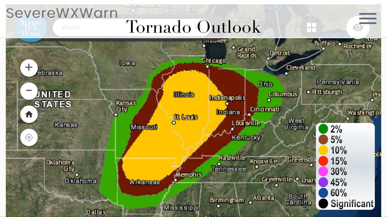
If storms can form in this regime across central/northern AR and
southern MO during the afternoon/evening, they will likely become
primarily discrete supercells and move rapidly northeastward at
50-60 kt across southeast MO toward southern IL. The combination of
vertical shear, buoyancy, and low-level moisture will conditionally
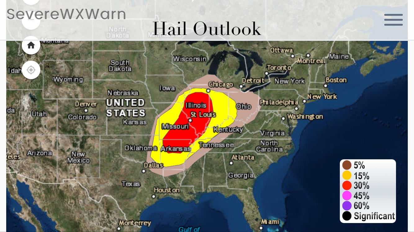
support a risk for strong tornadoes, while isolated very large hail
will also be possible.
…East of the surface cyclone into IL this afternoon/evening…
A few near-surface-based storms could form this afternoon and
persist into this evening immediately east of the surface cyclone,
along the warm front into central/northern IL as boundary layer
dewpoints increase to near 60 F beneath steep midlevel lapse rates.
Cloud breaks will dictate the degree of surface heating into
northeast MO, with potentially moderate buoyancy (MLCAPE 1000-1500
J/kg) along the north edge of the warm sector into central/northern
IL. If storms form within the north edge of the warm sector, strong
deep-layer and low-level shear will favor supercells with all severe
hazards possible.
…MO/AR to the OH Valley overnight…
As the surface cyclone develops northeastward to the Great Lakes,
the surface cold front will progress eastward to the Ark-La-Miss and
lower OH Valley by Thursday morning. One or more bands of
convection are likely along or just ahead of the front tonight into
Wednesday morning, with an accompanying risk for damaging winds and
hail. The wind and tornado risk will be maximized with embedded
bowing segments and/or supercell structures within or ahead of the
convective band/front, in an environment with strong vertical shear
and sufficient low-level moisture/buoyancy. There will also be some
risk for more discrete storm development farther south into western
and central AR late tonight.

2 thoughts on “Severe Weather Likely Today Across Indiana, Illinois, Missouri, Tennessee, Ohio, Kentucky & Surrounding States”
https://waterfallmagazine.com
Hey would you mind letting me know which webhost you’re working with?
I’ve loaded your blog in 3 completely different browsers and
I must say this blog loads a lot quicker then most.
Can you suggest a good hosting provider at a reasonable
price? Thanks a lot, I appreciate it!
Host Gator. Thanks for using SevereWXWarn