Severe weather will be possible today, tomorrow and Wednesday this week for parts of the Central and Eastern US. Thunderstorms, damaging winds, hail and some tornadoes will be possible as we start the week. We have provided below the summary for each day from the SPC and what to expect as well as some graphics from our Severe Weather Outlook map.
…SUMMARY…
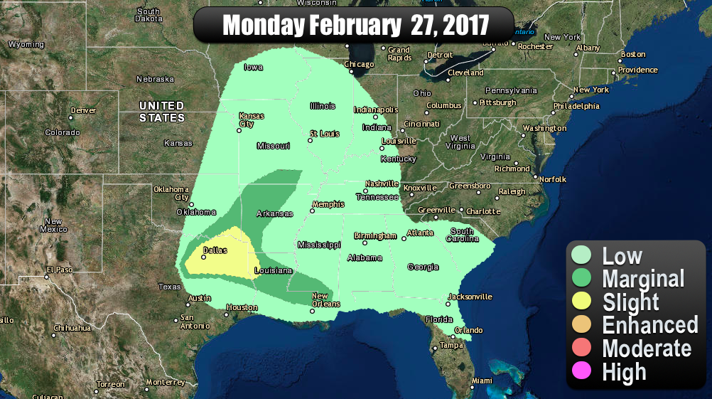
A few severe storms will be possible today over parts of Texas and
northwest Louisiana. Other strong storms will affect portions of
the Arklatex region and Lower Mississippi Valley.
…TX/LA…
Satellite imagery shows a shortwave trough axis extending from
western KY southwestward into central TX. Lift ahead of this trough
has resulted in a few showers and thunderstorms to develop over
central TX. The air mass ahead of the storms is moist and
moderately unstable, with afternoon MLCAPE values expected to range
from 1000-2000 J/kg. Relatively steep mid level lapse rates and
favorable deep-layer shear values suggest the risk of discrete
supercells capable of large hail. A remnant surface boundary
extends from northeast TX into central LA. Enhanced shear in
vicinity of this boundary causes some concern for an isolated
tornado or two later today if a storm moves into this zone.
…LA/MS…
Scattered thunderstorms will be possible farther east along the
boundary into southern LA and southern MS. Weaker thermodynamic and
wind parameters suggest only a marginal risk of severe storms in
this area, but an isolated severe hail or wind report cannot be
ruled out.
…SUMMARY…
Severe thunderstorms will be possible on Tuesday and Tuesday night
from eastern portions of Oklahoma and Texas northeastward into parts
of the lower and middle Mississippi Valley and Ohio Valley.
…Synopsis…
Model guidance remains in good agreement in showing a larger-scale
positively tilted mid-level trough moving from the Great
Basin/southern CA region eastward to the Great Plains by late
Tuesday night. As this trough move into the Plains states, it is
expected to take on a more neutral orientation, resulting in
strengthening deep-layer wind fields. A very strong 500-mb speed
max over northwest Mexico will move downstream and strengthen from
the southern Plains to the mid-MS and lower OH Valleys, likely
exceeding 100+ kt by Tuesday evening. Subsequent strengthening of a
broad southwesterly low-level jet will allow moisture to spread
poleward across the warm sector, with a large area of precipitable
water values exceeding 1-1.25 inches spreading across much of the
eastern half of the United States this forecast period.
At the surface, an area of low pressure should track from the
vicinity of the NE/IA border to the IL/WI border by 01/00Z, and then
across Lower MI to southwest Ontario. A trailing cold front will
advance east from the central Plains into the middle MS and lower OH
Valleys, while a second deepening area of low pressure tracks along
this boundary from OK Tuesday afternoon to central IL and Lower MI
Tuesday night. Concurrently, a warm front will advance northward
through the OH and upper TN Valleys.
…Ohio and Tennessee Valleys Tuesday morning and afternoon…
Despite the lack of height falls during the first half of the
forecast period, forcing for ascent attendant to a weak transient
midlevel impulse tracking across this region and low-level warm air
advection suggests an ongoing cluster and/or new thunderstorm
development will spread from west to east. The eastern extent of a
plume of steep midlevel lapse rates spreading east atop low-level
moistening should prove favorable for mainly elevated storms with
hail being the primary threat. However, forecast soundings suggest
some potential for a few surface-based storms, especially by Tuesday
afternoon across parts of northern AL through middle TN and eastern
KY. Vertically veering winds suggest a tornado and locally strong
wind gusts cannot be ruled out with these afternoon storms.
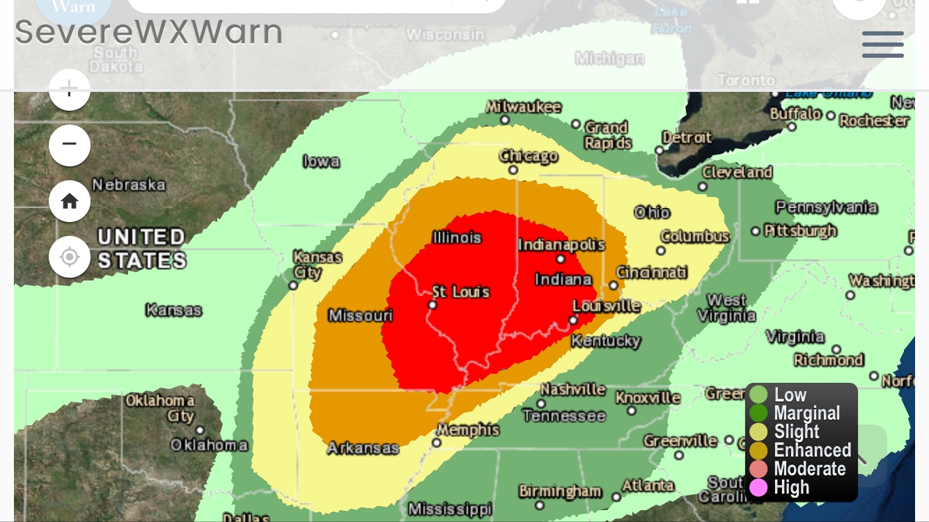
..ArkLaTex/eastern OK northeastward into the mid MS and OH Valleys
Tuesday afternoon through Tuesday night…
Consensus of deterministic and convective allowing models suggest
there will be the potential for several zones of storm development
late Tuesday afternoon through Tuesday evening across the full
extent of the severe risk areas from along the cold front with
northward extent to along low-level confluence zones farther south.
Given the 12Z ESRL HRRR and 12Z NAM 4km suggesting a broken band of
discrete storms developing from east-central MO into central and
northeast IL, the enhanced severe risk area has been expanded north
across to now include more of eastern MO and into central IL, with a
northward expansion of the slight and marginal risks as well.
Moderate instability and strengthening deep-layer and low-level
shear will favor all severe hazards, with some indication for a
strong tornado threat from parts of AR to southern IL along a
strengthening low-level jet enhancing hodograph curvature. The
potential exists for storms to evolve into a QLCS Tuesday evening
from Missouri into the lower OH Valley, with damaging winds and
meso-vorticity tornadoes being the primary threats.
Farther north, a marginal risk for severe storms may develop and
affect parts of east-central IA and southeast WI Tuesday afternoon
and evening, with the marginal risk expanded north to now include
these areas.
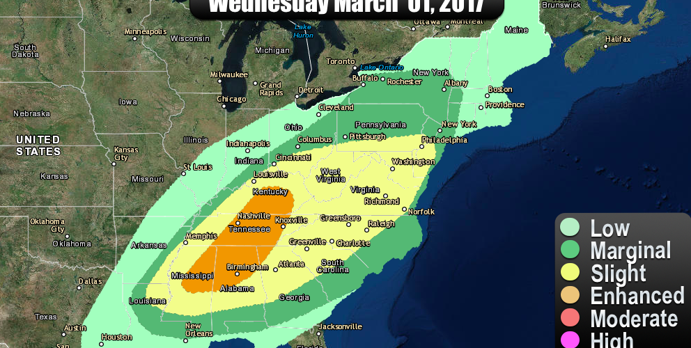
…SUMMARY…
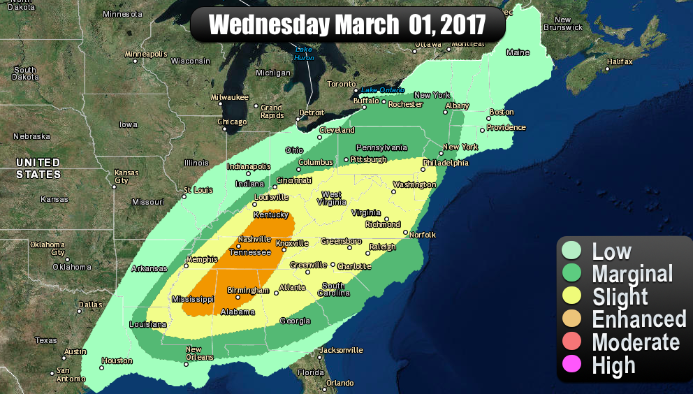
Strong to severe thunderstorms will be possible from the lower
Mississippi Valley northeastward across the Tennessee Valley and
southern Appalachians, and northward into parts of the Mid-Atlantic
states and perhaps portions of the Northeast.
…Synopsis…
A mid-level trough will move eastward across the Midwest and into
the lower Great Lakes during the day-3 period. The primary
mid-level vorticity maximum is progged to move from the middle MS
Valley east-northeastward into the lower Great Lakes by late
afternoon/early evening. A surface low will develop northeast from
Ontario to the St. Lawrence Seaway by late Wednesday night. A cold
front, initially near the lower OH Valley and lower MS Valley, will
sweep eastward across much of the Southeast and the East.
…lower MS Valley into the TN Valley and southern Appalachians and
north into the Mid-Atlantic states…
An ongoing and likely extensive squall line or broken bands of
storms are forecast near the MS River and lower OH Valley in
association with a cold front. Models vary slightly on the timing
of the fronts’ position during the early part of the day. However,
it seems likely substantial low-level moisture (upper 50s-mid 60s
dewpoints) will extend northeast from the lower MS Valley to the
WV/KY/OH/VA vicinity. Despite the prevalence of some mid-high cloud
cover, very strong low- to mid-tropospheric winds (50-70 kt
southwesterly flow at 700 mb) should aid in the development of
squall line with LEWPS/bowing segments capable of wind damage and
possibly a tornado where greater destabilization occurs. The
convective line will likely persist (owing to 60-90m 12 hour 500mb
height falls) and move across the Appalachian spine and possibly
yield a continued risk for damaging winds after dark despite the
loss of daytime heating. The diminishing of buoyancy with eastward
extend across the Southeast U.S. will probably lead to a
corresponding weakening in storm intensity and strong/severe storm
coverage.
…lower Great Lakes and Hudson Valley…
The northern periphery of appreciable low-level moisture will likely
move into the area as a warm front advances northward through a
large part of the Northeast. A storm cluster or two may be ongoing
early Wednesday and may delay destabilization. However, an influx
of mid-upper 50s dewpoints will likely result in several hundred
J/kg MUCAPE with a strong wind profile indicative of organized storm
structures. One or more bands may develop or move into the area
during the midday/afternoon as the effective front pushes eastward.
Damaging winds will probably be the main severe hazard. The main
limiting factor for higher coverage of strong to severe
thunderstorms will be weak instability.