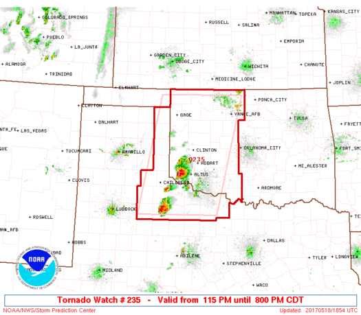

WW 235 TORNADO OK TX 181815Z – 190100Z

URGENT - IMMEDIATE BROADCAST REQUESTED
Tornado Watch Number 235
NWS Storm Prediction Center Norman OK
115 PM CDT Thu May 18 2017

The NWS Storm Prediction Center has issued a

* Tornado Watch for portions of
  western Oklahoma
  western north Texas

* Effective this Thursday afternoon and evening from 115 PM until
  800 PM CDT.

...THIS IS A PARTICULARLY DANGEROUS SITUATION...

* Primary threats include...
  Several tornadoes and a few intense tornadoes likely
  Scattered large hail likely with isolated very large hail events
    to 4 inches in diameter possible
  Scattered damaging winds and isolated significant gusts to 80
    mph possible

SUMMARY...Thunderstorms are forecast to develop/increase rapidly
over the next 1-2 hours across eastern portions of the Texas
Panhandle and into western Oklahoma and western north Texas,
spreading northeastward with time.  Multiple rounds of storm
redevelopment will be possible over western parts of the watch.  In
addition to the risk for very large/damaging hail and locally
damaging winds,  tornadoes -- a couple likely to be
significant/intense -- are expected.

The tornado watch area is approximately along and 75 statute miles
east and west of a line from 15 miles west northwest of Alva OK to
75 miles west southwest of Wichita Falls TX. For a complete
depiction of the watch see the associated watch outline update
(WOUS64 KWNS WOU5).

PRECAUTIONARY/PREPAREDNESS ACTIONS...

REMEMBER...A Tornado Watch means conditions are favorable for
tornadoes and severe thunderstorms in and close to the watch
area. Persons in these areas should be on the lookout for
threatening weather conditions and listen for later statements
and possible warnings.

&&

AVIATION...Tornadoes and a few severe thunderstorms with hail
surface and aloft to 4 inches. Extreme turbulence and surface wind
gusts to 70 knots. A few cumulonimbi with maximum tops to 500. Mean
storm motion vector 23040.

...Goss
Read more
Source: SPC