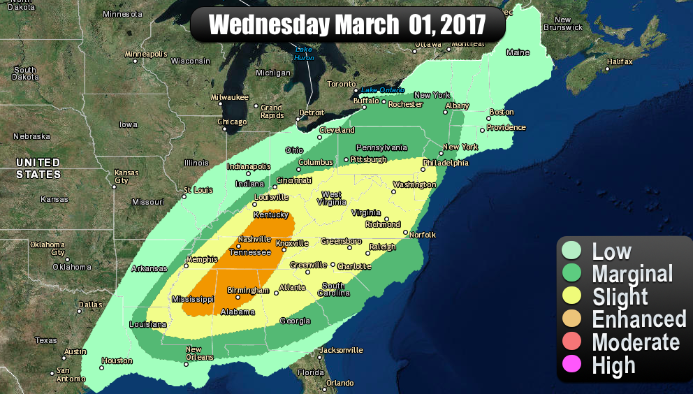
The Following is directly from the Storm Prediction Center at the National Weather Service.
…THERE IS A HIGH RISK OF SEVERE THUNDERSTORMS OVER PARTS OF
SOUTHERN AND CENTRAL GEORGIA…NORTHERN FL…AND EXTREME SOUTHEAST
AL…
…THERE IS A MODERATE RISK OF SEVERE THUNDERSTORMS OVER PARTS OF
AL…FL…GA…AND SC…
…THERE IS AN ENHANCED RISK OF SEVERE THUNDERSTORMS OVER PARTS OF
AL…FL…GA…SC…AND NC…
…THERE IS A SLIGHT RISK OF SEVERE THUNDERSTORMS OVER MUCH OF
AL…FL…GA…SC…AND NC…
…THERE IS A MARGINAL RISK OF SEVERE THUNDERSTORMS OVER MUCH OF THE
SOUTHEAST STATES…
…THERE IS A MARGINAL RISK OF SEVERE THUNDERSTORMS PARTS OF CENTRAL
CA…
…SUMMARY…
A severe thunderstorm and tornado outbreak is expected today across
north Florida and south Georgia, with the significant severe threat
also expected to extend southward into central Florida and
northeastward into South Carolina this evening.
…AN OUTBREAK OF SEVERE STORMS AND TORNADOES IS EXPECTED THIS
AFTERNOON AND EVENING OVER PARTS OF NORTHERN FLORIDA, AND
CENTRAL/SOUTHERN GEORGIA…
…Southern AL/North FL/Southern GA…
The late morning surface analysis shows a rapidly deepening low near
MOB, with a convectively reinforced warm front extending eastward
from the low along the FL/GA border. This low is forecast to deepen
over 12mb in the next 12 hours as it tracks northeastward. This
rapid cyclogenesis will be accompanied by very strong low and mid
level wind accelerations across parts of GA/FL. The result will be
a zone of impressive shear profiles in the warm-sector of the low,
along with ample low level moisture and rather steep lapse rates.
Forecast soundings in the HIGH risk area are characterized by
effective helicity values of 500-700 m2/s2 overlapping MLCAPE of
1000-1500 J/kg. This rare parameter space will support the risk of
long-track strong tornadoes across the HIGH risk area. Also, very
strong low and mid level winds and steep lapse rates suggest a
significant risk of bowing structures capable of widespread damaging
winds and large hail. The line of storms will eventually sag
southward across the entire FL Peninsula overnight with a continued
severe risk.
…Northeast AL/Northern GA…
As the rapidly deepening surface low lifts northeastward, a plume of
rather steep mid level lapse rates and strong winds aloft will wrap
around the low. This may result in an arc of strong to severe
storms affecting parts of northeast AL and northern GA later this
afternoon and evening. Ample low level vorticity along this arc may
be sufficient for a few tornadoes, along with large hail and
damaging wind gusts.
…Carolinas…
The convective evolution is uncertain over parts of SC/NC later
today due to the widespread upstream thunderstorm coverage expected,
and the persistent thunderstorm complex now over southeast GA.
Given the strength of the wind fields and cyclogenesis, there
remains a significant threat of severe storms spreading
northeastward across much of SC and into southeast NC after dark,
with damaging winds and a few tornadoes being the main threat. Its
unclear how far north and west this threat will extend, but have
lessened severe probabilities over parts of western/central NC where
cool air and clouds are likely to persist.
…Central CA Coast…
Multiple bands of showers and thunderstorms are expected to spread
inland and affect the central CA coast this afternoon. Cool
temperatures aloft and steep mid level lapse rates, combined with
the strong west-southwesterly winds aloft, will support a risk of
fast-moving bowing structures capable of locally damaging winds and
hail.


