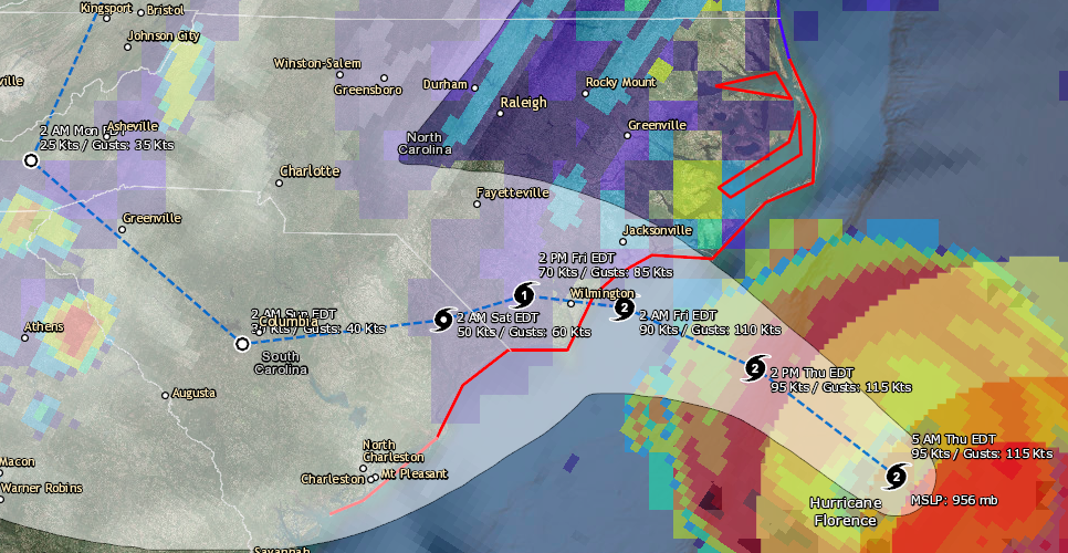
WATCHES AND WARNINGS
--------------------
CHANGES WITH THIS ADVISORY:

The Tropical Storm Watch from north of the North Carolina/Virginia
border to Cape Charles Light Virginia and for the Chesapeake Bay
south of New Point Comfort has been changed to a Tropical Storm
Warning.

SUMMARY OF WATCHES AND WARNINGS IN EFFECT:

A Storm Surge Warning is in effect for...
* South Santee River South Carolina to Duck North Carolina
* Albemarle and Pamlico Sounds, including the Neuse and Pamlico
Rivers

A Storm Surge Watch is in effect for...
* Edisto Beach South Carolina to South Santee River South Carolina
* North of Duck North Carolina to the North Carolina/Virginia border

A Hurricane Warning is in effect for...
* South Santee River South Carolina to Duck North Carolina
* Albemarle and Pamlico Sounds

A Hurricane Watch is in effect for...
* Edisto Beach South Carolina to South Santee River South Carolina

A Tropical Storm Warning is in effect for...
* North of Duck North Carolina to Cape Charles Light Virginia
* Chesapeake Bay south of New Point Comfort

Interests elsewhere in the southeastern and mid-Atlantic states
should monitor the progress of Florence.

A Storm Surge Warning means there is a danger of life-threatening
inundation, from rising water moving inland from the coastline. For
a depiction of areas at risk, please see the National Weather
Service Storm Surge Watch/Warning Graphic, available at
hurricanes.gov.  This is a life-threatening situation.  Persons
located within these areas should take all necessary actions to
protect life and property from rising water and the potential for
other dangerous conditions.  Promptly follow evacuation and other
instructions from local officials.

A Storm Surge Watch means there is a possibility of life-
threatening inundation, from rising water moving inland from the
coastline.

A Hurricane Warning means that hurricane conditions are expected
somewhere within the warning area, in this case within the next 12
to 24 hours.  Preparations to protect life and property should be
nearing completion.

A Hurricane Watch means that hurricane conditions are possible
within the watch area.  A watch is typically issued 48 hours
before the anticipated first occurrence of tropical-storm-force
winds, conditions that make outside preparations difficult or
dangerous.

A Tropical Storm Warning means that tropical storm conditions are
expected somewhere within the warning area.

For storm information specific to your area, including possible
inland watches and warnings, please monitor products issued by your
local National Weather Service forecast office.


DISCUSSION AND OUTLOOK
----------------------
At 500 AM EDT (0900 UTC), the center of Hurricane Florence was
located near latitude 32.8 North, longitude 74.7 West. Florence is
moving toward the northwest near 15 mph (24 km/h), and this general
motion, accompanied by a gradual decrease in forward speed, is
expected to continue through today.  A turn to the west-northwest
and west at an even slower forward speed is expected tonight and
Friday, and a slow west-southwestward motion is forecast Friday
night and Saturday.  On the forecast track, the center of Florence
will approach the coasts of North and South Carolina later today,
then move near or over the coast of southern North Carolina and
eastern South Carolina in the hurricane warning area tonight and
Friday. A slow motion over eastern South Carolina is forecast
Friday night through Saturday night.

Maximum sustained winds are near 110 mph (175 km/h) with higher
gusts.  Little change in strength is expected before the center
reaches the coast, with weakening expected after the center moves
inland.

Florence is a large hurricane.  Hurricane-force winds extend outward
up to 80 miles (130 km) from the center and tropical-storm-force
winds extend outward up to 195 miles (315 km). A NOAA buoy located
about 80 miles (130 km) south of the center of Florence has
recently reported sustained winds of 52 mph (83 km/h) with a gust
to 64 mph (104 km/h).

The estimated minimum central pressure is 956 mb (28.23 inches).


HAZARDS AFFECTING LAND
----------------------
STORM SURGE:  The combination of a dangerous storm surge and the
tide will cause normally dry areas near the coast to be flooded by
rising waters moving inland from the shoreline.  The water has the
potential to reach the following heights above ground if peak surge
occurs at the time of high tide...

Cape Fear NC to Cape Lookout NC, including the Neuse, Pamlico,
Pungo, and Bay Rivers...9-13 ft
North Myrtle Beach SC to Cape Fear NC...6-9 ft
Cape Lookout NC to Ocracoke Inlet NC...6-9 ft
South Santee River SC to North Myrtle Beach SC...4-6 ft
Ocracoke Inlet NC to Salvo NC...4-6 ft
Salvo NC to North Carolina/Virginia Border...2-4 ft
Edisto Beach SC to South Santee River SC...2-4 ft

The deepest water will occur along the immediate coast in areas of
onshore winds, where the surge will be accompanied by large and
destructive waves.  Surge-related flooding depends on the relative
timing of the surge and the tidal cycle, and can vary greatly over
short distances.  For information specific to your area, please see
products issued by your local National Weather Service forecast
office.

RAINFALL: Florence is expected to produce heavy and excessive
rainfall in the following areas...

Coastal North Carolina into far northeastern South Carolina...20 to
30 inches, isolated 40 inches. This rainfall would produce
catastrophic flash flooding and prolonged significant river
flooding.

Rest of South and North Carolina into southwest Virginia...6 to 12
inches, isolated 24 inches.

WIND:  Hurricane conditions are expected to reach the coast within
the hurricane warning area this evening or early Friday.  Winds are
expected to first reach tropical storm strength by later this
morning or early this afternoon, making outside preparations
difficult or dangerous.  Preparations to protect life and property
should be nearing completion.

TORNADOES:  A few tornadoes are possible in eastern North Carolina
through Friday.

SURF:  Swells generated by Florence are affecting Bermuda, portions
of the U.S. East Coast, and the northwestern and central Bahamas.
These swells are likely to cause life-threatening surf and rip
current conditions. Please consult products from your local weather
office.

The satellite presentation of Florence has changed little overnight
with the eye waxing and waning in infrared imagery.  The eye has
moved into NWS radar range and can be seen in radar data from
Morehead City and Wilmington NWS 88-D imagery.  An 0616 UTC
AMSR2 microwave overpass indicated that the convection over the
southern and southeastern portions of the storm is still disrupted,
and that the eyewall was open to the southeast.  An Air Force
Hurricane Hunter aircraft also reported that the eyewall was not
fully intact on its last pass through the storm just after that
time.  The Air Force plane measured a peak 700-mb flight level wind
of 102 kt and peak SFMR winds of 85 kt during the mission.  These
data suggest that the intensity may be slightly lower, but the
initial intensity has been maintained at 95 kt, since the plane
may not have sampled the strongest winds. Another Air Force
plane will be in Florence shortly, and should provide a better
assessment of the intensity of the hurricane.  As mentioned in
the previous discussion, it appears that some southern shear has
caused the degradation of the inner core.  The global models suggest
that this shear will relax today while Florence moves over warm
waters, however, given the current storm structure, little overall
change in strength is anticipated as Florence approaches the coast.
Gradual weakening should occur as the hurricane interacts with land
in 24-36 h, with a faster rate of weakening predicted once Florence
moves farther inland.

Florence is moving northwestward or 315 degrees at 13 kt. A
developing mid-level ridge over the north-central United States
should cause the forward speed of the hurricane to decrease today.
As the steering currents collapse tonight and Friday, Florence is
forecast to drift westward or west-southwestward and continue that
slow motion into the weekend.  The global models predict that the
ridge will slide eastward over the weekend, which should allow
Florence to turn northwestward and northward by the end of the
forecast period.  Although there is still some spread in the
guidance by 48 hours, with the GFS along the northern side of the
guidance envelope, and the ECWMF along the southern edge, the
various consensus aids have moved little.  As a result, the new NHC
forecast track is very similar to the previous advisory.

Aircraft and satellite wind data show that Florence is a large
hurricane.  Life-threatening storm surge, heavy rainfall, and
damaging wind will cover a large area regardless of exactly where
the center of Florence moves.


Key Messages:

1. A life-threatening storm surge is now highly likely along
portions of the coastlines of South Carolina and North Carolina, and
a Storm Surge Warning is in effect for a portion of this area.  All
interests in these areas should complete preparations and follow any
advice given by local officials.

2. Life-threatening, catastrophic flash flooding and prolonged
significant river flooding are likely over portions of the Carolinas
and the southern and central Appalachians late this week into early
next week, as Florence is expected to slow down as it approaches the
coast and moves inland.

3. Damaging hurricane-force winds are likely along portions of the
coasts of South Carolina and North Carolina, and a Hurricane Warning
is in effect. Strong winds could also spread inland into portions
of the Carolinas.

4. Large swells affecting Bermuda, portions of the U.S. East
Coast, and the northwestern and central Bahamas will continue this
week, resulting in life-threatening surf and rip currents.


FORECAST POSITIONS AND MAX WINDS

INIT  13/0900Z 32.8N  74.7W   95 KT 110 MPH
 12H  13/1800Z 33.7N  76.1W   95 KT 110 MPH
 24H  14/0600Z 34.2N  77.4W   90 KT 105 MPH
 36H  14/1800Z 34.3N  78.4W   70 KT  80 MPH...INLAND
 48H  15/0600Z 34.1N  79.2W   50 KT  60 MPH...INLAND
 72H  16/0600Z 33.9N  81.2W   30 KT  35 MPH...INLAND
 96H  17/0600Z 35.4N  83.3W   25 KT  30 MPH...INLAND
120H  18/0600Z 39.5N  81.0W   20 KT  25 MPH...POST-TROP/REMNT LOW

Courtesy: National Hurricane Center
You may also like
Today SevereWXWarn is proud to announce that we are launch an online weather radio application. Apps will also be released in the […]
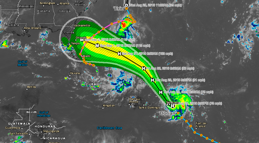
Dorian is now a hurricane located near St Thomas. Maximum sustained winds are currently 75 MPH with a central pressure of 997 […]
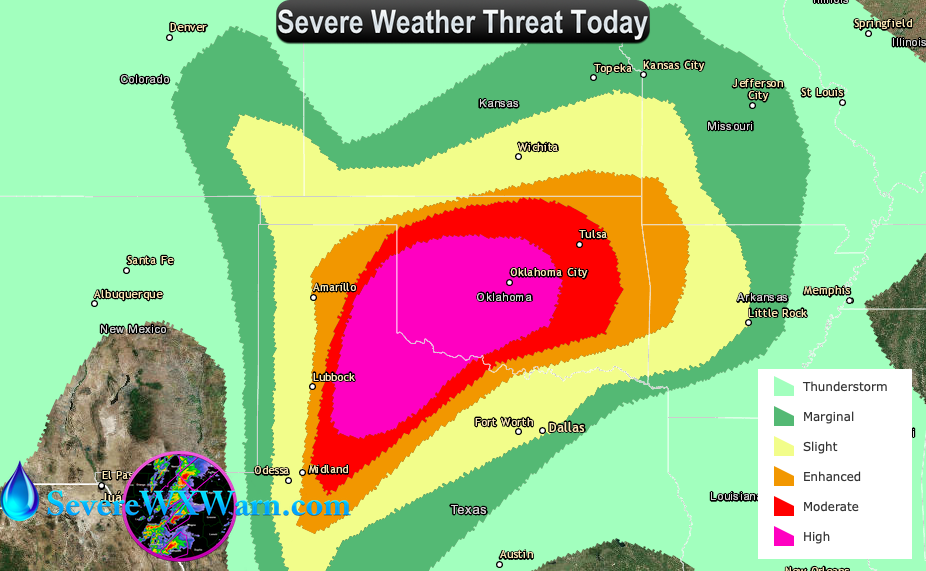
An outbreak of tornadoes, some potentially long-track and violent, is expected today into this evening over portions of northwest Texas into western […]