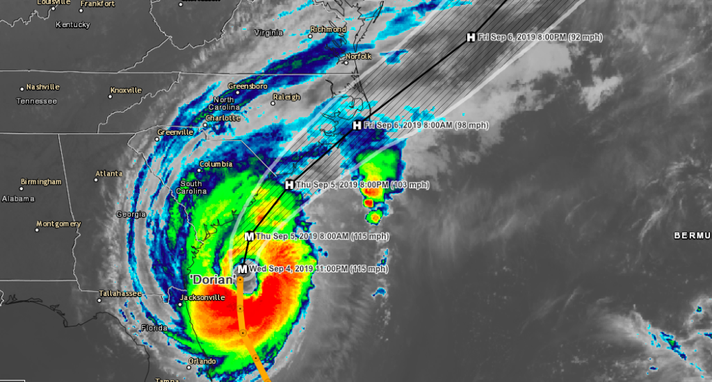
As of 11 p.m. Wednesday Hurricane Dorian was upgraded to a major category 3 hurricane, which means the storm now has winds of 115 mph. It is currently moving at 7 mph to the north and is expected to make a northwest turn on Thursday. Significant coastal flooding is expected along the southeastern coast. Hurricane force winds extend 60 miles from the center with tropical storm force winds extending 195 miles from the center.

Like us on Facebook
Download our Hurricane Tracker (Apple)
Download our Hurricane Tracker (Android)
View our Hurricane Tracker (Desktop)

Storm Surge Warning
- Mouth of St. Mary's River to Poquoson VA
- Pamlico and Albemarle Sounds
- Neuse and Pamlico Rivers
- Hampton Roads

Hurricane Warning
- North of Savannah River to the North Carolina/Virginia border
- Pamlico and Albemarle Sounds

Hurricane Watch
- Mouth of St. Mary's River to Savannah River

Tropical Storm Warning
- Mouth of St. Mary's River to Savannah River
- North Carolina/Virginia border to Chincoteague VA
- Chesapeake Bay from Smith Point southward

Tropical Storm Watch
- North of Chincoteague VA to Fenwick Island DE
- Chesapeake Bay from Smith Point to Drum Point
- Tidal Potomac south of Cobb Island

STORM SURGE (expected)
- Isle of Palms to Myrtle Beach SC...5 to 8 ft
- Savannah River to Isle of Palms SC...4 to 7 ft
- Myrtle Beach SC to Cape Lookout NC...4 to 7 ft
- Cape Lookout NC to Duck NC, including Pamlico and Albemarle Sounds
  and the Neuse and Pamlico Rivers...4 to 6 ft
- North of Mouth of St. Mary's River to Savannah River...3 to 5 ft
- Duck NC to Poquoson VA, including Hampton Roads...2 to 4 ft

RAINFALL (expected)
- Coastal Carolinas...6 to 12 inches, isolated 15 inches.
- Coastal Georgia...2 to 4 inches, isolated 6 inches
- Far southeast Virginia...3 to 6 inches.