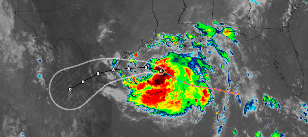
NOAA Hurricane Hunters have confirmed the Tropical Storm Hanna has slightly strengthened and has it's eye on Southern Texas. The storm currently has sustained winds of 45 mph and is moving northwest and 9 mph. A Tropical Storm Warning is in effect for the Mouth of the Rio Grande to San Luis Pass Texas. A turn toward the west is expected tonight, followed by a westward to west-southwestward motion through the weekend. On the forecast track, center of Hanna should make landfall along the Texas coast within the warning area Saturday afternoon or evening. Gradual strengthening is expected until the tropical cyclone makes landfall. Steady weakening is expected after Hanna moves inland. Tropical-storm-force winds extend outward up to 60 miles from the center. Tropical storm conditions are expected in the warning area by tonight or Saturday morning. Hanna is expected to produce 4 to 8 inches of rain with isolated maximum totals of 12 inches through Sunday night in south Texas. 3 to 5 inches of rain is expected along the upper Texas and Louisiana coasts, and inland to the Mexican states of Coahuila, Nuevo Leon, and northern Tamaulipas. The combination of storm surge and the tide will cause normally dry areas near the coast to be flooded by rising waters moving inland from the shoreline. Swells generated by Hanna are expected to increase and affect much of the Texas and Louisiana coasts during the next few days. These swells are likely to cause life-threatening surf and rip current conditions.
- Credit: National Hurricane Center
