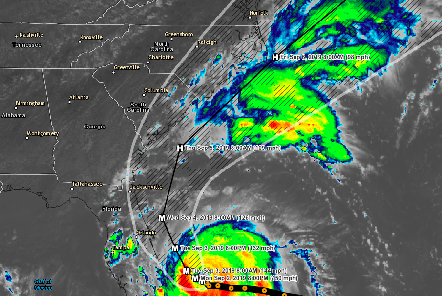
Life Threatening storm surge and winds are continuing to pound the Grand Bahama Island. Dorian is currently located about 20 miles Northeast of Freeport with max winds of 150 mph. It has nearly stalled over the island with a northwesterly movement of 1 mph. Anyone along the costal regions from the Virginia to Florida should monitor the system closely. Now is the time to be prepared and have a plan in place. The current speed and direction of travel is expected for the next day or two with a turn to the north likely on Wednesday. With the currently projections the storm will continue to pound the Grand Bahama Island tonight into tomorrow. The current track will take the storm close to the eastern Florida cost tonight and throughout Wednesday. Continuing up the coast the storm will hover close to the Georgia and South Carolina coasts Wednesday night into Thursday. Thursday into Friday the storm is expected to track closely to the Outer Banks of North Carolina. Gradual weakening is expected over the coming days, though this system is expected to remain a very dangerous storm. The Bahamas could see anywhere from 12-30 inches of rain from the system, 5-15 inches can also be expected along the coastal regions from Florida the the Carolina's.

Storm Timing & Winds
Monday Evening into Tuesday (off Florida coast)
 - Bahamas and Southeastern Florida 120-150 mph winds

Wednesday
 - Central Florida to South Carolina 110-120 mph winds (off coast)

Thursday (US Landfall possible in Southern OBX depending on track)
 - South Carolina to Southern OBX 100-115 mph winds (off coast)

Thursday Evening into Friday
 - North Carolina OBX 95-110 mph winds (off coast)

Like us on Facebook
Download our Hurricane Tracker (Apple)
Download our Hurricane Tracker (Android)
View our Hurricane Tracker (Desktop)
